Introduction
In order to map out the Bridgwater town centre, districts and surrounding villages, we have followed the principles as laid out in section three ‘Planning for Cycling‘ within the Local Transport Note (LTN 1/20) Cycle Infrastructure Design document. The fundamental stages are aligned to the ‘Local Walking & Cycling Infrastructure Plan (LWCIP)’ technical guidance document and Somerset County Council (SCC) use the methodology for the LWCIP process by creating a ‘Technical Note‘ produced by SCC contractors to start the process of developing a Bridgwater network of cycling & walking planning. We have follow the SCC technical note and used our own experience and expertise to follow the stages of LTN 1/20 section 3 – ‘Planning & Cycling Fundamentals‘.
Bridgwater Detailed Map: Shows existing routes in Brown, Amber and Green lines.
Town Centre Map: Detailed view of town centre marked with local attractions and places of interest.
Attractors Map: Shows cycling and walking attractors in priority order. Note, scanned image, quality is limited
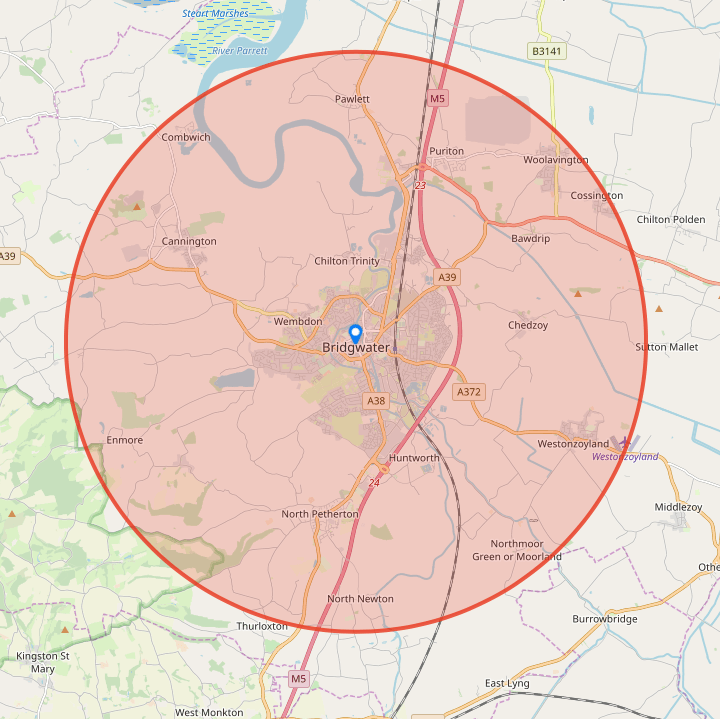
Bridgwater Area Map
The graphic of Bridgwater here and its outlying villages, shows the local landscape that we as a group consider to be our main areas of primary infrastructure focus (use graphic to get access to a larger detailed map). We have conducted extensive cycling audits in all of these areas within the circle shown with our aims are; to try and link the surrounding villages to the town centre (north, south, west and west corridors) and particularly promote the building of a significant amount of commuter routes within the town centre and district areas.

Bridgwater Detailed Map
This map that shows all the ‘ideal’ corridors and routes within the Bridgwater and surrounding areas, click on the image adjacent to see routes in more detail. The cycling routes are colour coding in Brown, Amber & Green lines – see the infrastructure coding guide below. This map has been created with the support of Bridgwater Town Council.
Please note: Map will hopefully be updated annually
Infrastructure Corridor/Route Coding Principles (Brown, Amber or Green)
Brown: This code is stating that walkers & cyclists have no choice but to mix with either heavy or light traffic and/or vehicles will come close to the line that they are travelling. Route or part of the route section is dangerous, unsafe and accidents are a definite possibility.
Amber: This coding is aligned to the quiet areas of the town & surrounding villages. Although the users will generally feel safe on these route sections, there is still the possibility of minor accidents occurring and also that there will be a number of defined safety hazards.
Green: This route coding indicates that safe segregated or traffic free paths are available. These routes not only feel safe, but there is a definite separation of walker/cyclist from all kinds of traffic. It is noted that although junctions & crossings may be of a safe design and considered Green, they none-the-less have to be safely navigated by the user.

Bridgwater Town Centre Map
This map has been created in conjunction with the support of Bridgwater Town Council and shows the key town centre attractions and places of interest. Click on map image to access a deeper view and to get an insight into difficulties of creating space and the concept of trying to build a new design infrastructure within the town centre.
Please note: Map will hopefully be updated annually

BACC Attractors Map
To combine the key trend tools and to fully understand the breath and scope of where the ideal corridor and link routes should be built, BACC produced a ‘Key Trip Attractors‘ map, which identified the all the sites and locations that cyclists are likely to be attracted too.
This map was laid out in ‘Attractor Type Priorities’, Red areas (3 points); main attractors for cyclists currently i.e. large schools & college, parks, etc. Amber areas (2 points); locations that people currently cycle to and have the scope for increase i.e. local business units, employers and large shops, etc. Blue areas (1 points); all other locations that may or may not have people visit them on a bicycle i.e. town centre shops, small business units, library, museum, churches, etc.
LTN Section 3 Planning & Cycling Fundamentals
- Determining Scope: By defining the geographical extent of Bridgwater. BACC have determined the scope of our area – see ‘Bridgwater Area Map‘ and the governance that we need to applied too (by using the SCC ‘Technical Note‘ defined document and BACC’s added expertise & input)
- Information Gathering: To identify the existing patterns and potential scope for the cycling and walking infrastructure in Bridgwater, we have completed extensive work under our ‘Cycle Audits‘ process. This initially determine all feasible routes – feasible being those routes that would potentially work in the future, that currently existed, needed to be improved and/or a complete new route or corridor having to be built. This stage did not determine the ‘exact’ routes that required to be improved, but laid down all the fundamental ground work for this to be interwoven into the ‘Prioritising Improvements’ stage
- Network Planning for Cycling: To identify key trip generators, core zones and routes and to determine were improvements were required. The SCC ‘Technical Note‘ provided four key trend tools to start this process off; 1) ‘Origins & Destinations‘ firstly determining the principles locations to identify key trip generators, 2) ‘Desire Lines‘, a way of creating straight line corridors across the town based on previously determined main destinations and from here determining ‘trend’ lines, 3) ‘Propensity to Cycle Tool‘, this uses 2011 census journey data to forecast future cycle and walking flows within our town and 4) ‘Prioritising Routes for Audit‘, which gave the initial identification of the network planning areas that required detail survey work
- Attractor Mapping: To combine the four key trend tools noted above and to fully understand the breath and scope of where the ideal corridors and link routes should be worked on, improved or newly built, BACC produced a an ‘Attractors Map‘, which identified the all the sites and locations that cyclists are likely to be attracted too
- Bridgwater Route Mapping: To provide an easy way of showing all the key routes across town a ‘BACC Detailed Map‘, this is our main tool to demonstrate Bridgwater network improvements and also a ‘Bridgwater Town Centre Map‘ was produced
- Prioritising Improvements: Developing a phase plan for future investment. This stage will come from a combination of SCC and BACC work under the principles and guidance laid out within the LWCIP process – see ‘Cycle Audits‘. In order to create quality new infrastructure we must firstly produce ‘oven ready packages’ for each discrete prioritise corridor or route, this us carried out by either creating ‘Feasibility Studies‘ (new projects under the LWCIP process) or by aligning and working with developer existing and future schemes and reviewing design drawing using ‘Intervention Reports‘. Also see ‘Infrastructure‘ page for all current & future schemes
- Intregration and Application: To integrate the outputs from the priorities improvements into our current policies and strategies. This is both carried out under the SCC LWCIP process strategies and within the towns main planning documentation – see ‘Planning‘ for full details of Bridgwater long term plans


