Introduction
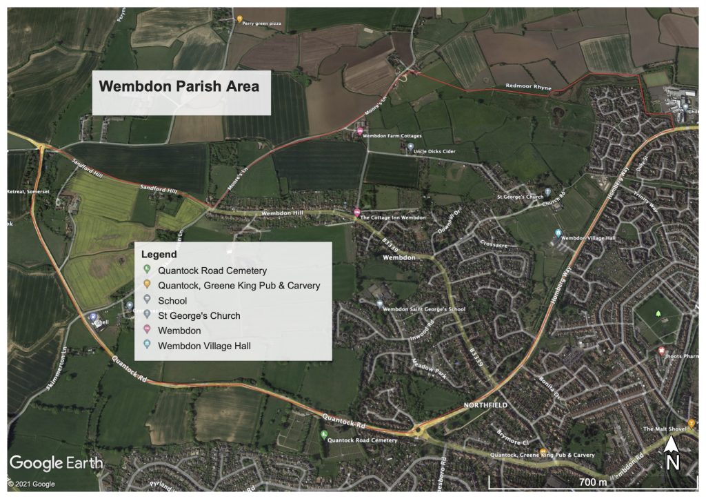
The cycling and walking infrastructure across the Wembdon Parish is in reasonable good order. Many routes exist that are within the Amber or Green risk code. The main west corridor into town centre goes through Wembdon and takes the route of; Sandford Corner, through Sandford & Wembdon Hills and then splits at Church Road in to two distinct routes. Route 1, continues on Wembdon Rise, crosses the Homberg Way, in to ‘old’ Wembdon Road, left at cemetery towards & through Halesleigh Road, right into Victoria Road, left on Lyndale Avenue to the Docks Area. Town centre is now close by. Route 2, left on Wembdon Hill into Church road, all the way via Church path to the Homberg way, cross over, cycle path to Crowpill lane, cross Chilton Street, into Saltlands, right into Linham Road and onto the River Parrett bank to the docks area – continue on river bank to town centre.
The main key routes are listed below, however developers will be building significant housing estates in Wembdon and towards Sandford. Therefore other new routes will require audit surveys and BACC reviews. Watch this space..!

Wembdon Key Safe Routes
- Sandford Corner all the way through to Wembdon Rise – Amber
- Skimmerton Lane (from Wembdon Hill to Quantock Road) – Amber/Red
- Church Road (via Church Path) to the Homberg Way – Amber/Green
- Wares Lane link to Wembdon Common Path – Not Available
- Meadow Park & Brantwood Road (link to Wembdon Primary) – Green/Amber
- Homberg Way to Western Way (NDR route) – Green
Infrastructure risk coding ‘Red, Amber & Green‘ explanation is given below……….
Infrastructure Risk Code (Red, Amber or Green)
The risk code is based around the five (5) core design principles as laid out within the Local Transport Note (LTN 1/20), which are; Coherence (connectivity of route sections & junctions), Directness (shortest & safest route between places), Safety (design, peoples and a perceived safe passage), Comfort (both in street design and feel) & Attractiveness (off road, traffic free, good environment). The code though is primarily looking at both pedrestain & cyclist Safety.
Red: This code is stating that walkers and cyclists have no choice but to mix with either heavy or light traffic and/or vehicles will come close to the line that they are travelling. Route or part of the route section is dangerous, unsafe and accidents are a definite possibility.
Amber: This coding is aligned to the quiet areas of the town & surrounding villages. Although the users will generally feel safe on these route sections, there is still the possibility of minor accidents occurring and also that there will be a number of defined safety hazards.
Green: This route coding indicates that safe segregated or traffic free paths are available. These routes not only feel safe, but there is a definite separation of walker/cyclist from all kinds of traffic. It is noted that although junctions & crossings may be of a safe design and considered Green, they none-the-less have to be safely navigated by the user.
